Dingli | Exploring Malta
Dingli is a village in the Northern Region of Malta, located on the southwestern coast of the main island. The village is also known by its Maltese name, Ħad-Dingli. With a population of around 3,800 inhabitants, it is a quiet rural community. The village is most famous for the Dingli Cliffs, which are the highest point in the Maltese Islands. This dramatic coastal landscape is a major natural landmark and a popular tourist attraction. The village itself is situated on a plateau, a short distance inland from the edge of the cliffs.
The character of Dingli is that of a traditional Maltese agricultural village that is defined by its relationship with the rugged coastline. Its identity is almost entirely tied to the famous cliffs that bear its name. The village serves as a gateway for visitors wishing to experience the panoramic sea views and the natural garrigue landscape of this part of Malta. The village center is a small, quiet hub with a large parish church. This tranquil, rural atmosphere stands in contrast to the more densely populated and bustling towns in the central and eastern parts of the island.
Blog Posts From our visits to Dingli


The History of Dingli
The history of Dingli is that of a rural parish that has been inhabited for centuries but was only formally established in the early modern period. Its development has been shaped by its remote location and its agricultural landscape. The story of Dingli is one of a small farming community that later became a key strategic point for modern communications technology during the British period. This has created a unique blend of ancient rural life and 20th-century history.
An Ancient Parish
The area around Dingli has been inhabited for thousands of years. For centuries, the main settlement in the area was a small village known as Ħal Tartarni, which was located a short distance to the east of the current village. Over time, the inhabitants of this older village began to move closer to their fields in the area that is now Dingli. The modern village of Dingli eventually grew and became its own independent parish in 1678. The village is named after the English knight Sir Thomas Dingley, who was a member of the Order of St. John and owned land in the area.
The British Period and Modern Times
Dingli continued its existence as a quiet, agricultural village for centuries. It was largely untouched by the major military and commercial developments that took place in the harbor areas of Malta. A key moment in its modern history came in 1939, during the British colonial period. The British Royal Air Force built the first radar station in Malta on the high ground at Dingli Cliffs. This was the first of a chain of radar stations that would be crucial for the defense of the island during World War II. In the post-independence era, the radar station has been modernized and is still in use for air traffic control. The village has also grown as a residential area, attracting people who prefer a quieter, rural lifestyle.


Sights in Dingli
The main sights in and around Dingli are focused on its spectacular coastline and its historic landmarks. The famous cliffs are the primary attraction, but the area also includes several historic chapels and is close to other major national sights.
Dingli Cliffs
The Dingli Cliffs are the main attraction in the area and one of the most famous natural landmarks in Malta. The cliffs are located on the southwestern coast of the island and are the highest point in the Maltese Islands. At a location known as Ta’ Dmejrek, the cliffs reach a height of 253 meters above sea level. The cliffs offer a dramatic and amazing view of the Mediterranean Sea. The direction of the cliffs makes it a great place to enjoy the sunset. A road runs along the top of the cliffs, providing access to several viewpoints.
Saint Mary Magdalene Chapel
Located in a prominent position on the very edge of the Dingli Cliffs is the Saint Mary Magdalene Chapel. This small Roman Catholic chapel is dedicated to Mary Magdalene. The current chapel was built in 1646, though a chapel has existed on this site since the 15th century. It is a very simple, single-room building. Its location, perched on the edge of the high cliffs, makes it one of the most photographed chapels in Malta. It is a popular destination for visitors walking along the cliffs.
Parish Church of the Assumption
The full name of the church is the Parish Church of the Assumption of the Blessed Virgin Mary into Heaven, which is Knisja Parrokkjali ta’ Santa Marija Assunta in Maltese. This is the main parish church of Dingli and is located in the center of the village. The construction of the current, large church began in 1903, and it replaced a former parish church from the 17th century. The church is a major landmark in the village and is the center of the annual village festa.
Dingli Radar
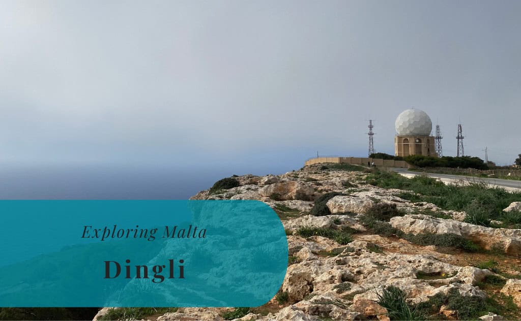
The radar station at Dingli Cliffs is a major landmark. The first radar was completed here in 1939. The most distinctive feature of the current station is the large, white dome that encloses the radar antenna, which is known locally as the “golf ball” or Il-Ballun. Since the departure of the British military in 1979, the radar station has been controlled by the Maltese authorities. Today, it is used for air traffic control for the Malta International Airport.
Buskett Gardens
Located a short drive from Dingli is the Buskett Gardens. This is one of the few woodland areas in Malta and is the largest. The gardens were originally planted by the Knights of St. John to be used as a hunting reserve. Today, it is a large public park with a mix of native and imported trees. It is a popular destination for walks, especially during the spring and after rainfall when the area is at its greenest.
Verdala Palace
Overlooking the Buskett Gardens is the Verdala Palace. This is the official summer residence of the President of Malta. The palace was built by Grand Master Hugues Loubenx de Verdalle in 1586. It is an elegant Renaissance building with four corner towers. While the palace itself is not open to the public, its impressive exterior can be viewed from the gardens and the surrounding roads. It is a major architectural landmark in the region.
Dingli with Kids
Dingli can be considered a safe place to visit with kids due to its lower traffic and calmer streets compared to the main tourist towns. However, some children might find the village a bit boring, as there are limited arranged activities for them in the area. The main attraction for families is the open space and the opportunity for walks in the countryside along the cliffs. The primary safety concern is to be very careful near the edge of the high, unfenced cliffs.
Playgrounds in Dingli
There is a small family park located on the northwestern outskirts of the village. The Dingli Family Park includes a small playground. However, it has received mixed reviews. For larger and more modern playgrounds, a visit to the nearby town of Rabat would be necessary.


Sports in Dingli
The sporting life in Dingli is focused on its local football club. The club is a key part of the local community.
Football
Football is a popular sport in Dingli, as it is throughout Malta. The local club has a long history and has had periods of competing at the highest level of Maltese football.
Dingli Swallows F.C.
The main football club is Dingli Swallows F.C. The club was founded in 1948. They have a history that includes a season competing in the Maltese Premier League, the top tier of Maltese football, in the 2009-10 season. Dingli Swallows F.C. currently compete in the lower divisions. They play their home games at a local sports ground.


Getting Around in Dingli
Navigating the village of Dingli and its immediate surroundings is best done on foot or by local bus. The village itself is small and walkable. The main attraction, the cliffs, is a long stretch of coastline that is best explored on foot.
On Foot: The Village and Cliffs
Walking is the best way to explore the central part of Dingli. The parish church and the main streets of the village are all located within a small area. The most popular activity is walking along the road and the paths that run along the top of the Dingli Cliffs. This allows visitors to experience the panoramic views.
Local Buses
The public transport in Malta is based on an extensive network of buses operated by Malta Public Transport. A bus route connects Dingli with the nearby town of Rabat and its main bus interchange. From Rabat, it is possible to connect to bus routes that serve all other parts of the island.
How to Get to Dingli
Reaching the village of Dingli requires travel to the southwestern part of the main island of Malta. The village is located in a rural and somewhat remote area. A car or the national bus network are the primary means of reaching the village.
The Open Road: Driving to Dingli
Driving to Dingli is possible from all other parts of the island. The village is connected by a network of local roads to the main road system of Malta. The main route to the area is via the nearby town of Rabat. A car provides the flexibility to explore the entire stretch of the Dingli Cliffs and the other nearby sights, such as Buskett Gardens.
Arriving by Air: Malta International Airport
The primary and sole gateway to the country is Malta International Airport (MLA). It is located in the town of Luqa, approximately 10 kilometers from Dingli. The airport is well-connected to major cities across Europe, the Middle East, and North Africa. From the airport, a taxi, a ride-sharing service, or a combination of bus services via Rabat is the most common way to reach Dingli.
Connecting by Coach
There are no major long-distance coach services in Malta due to the small size of the island. The entire country is served by the integrated national bus network operated by Malta Public Transport. To reach Dingli, travelers would typically need to take a bus to the main bus terminal in Valletta or to the interchange at Rabat, and then transfer to the bus route that serves Dingli.
On Track: The Absence of Rail
There is no train service in Malta. The country does not have a railway network. Therefore, it is not possible to reach Dingli by train. All overland travel on the island must be done by road.
An International Ferry Approach
It is possible to arrive in Malta by ferry. The main ferry terminal is located at the Valletta Waterfront. There are regular car and passenger ferry services that connect Malta with the port of Pozzallo in Sicily, Italy. From the ferry terminal in Valletta, it is a journey by bus or taxi to reach the village of Dingli.
Driving Distances
The driving distance from 10 regional cities, according to Google Maps:
- Rabat, Malta – 2 kilometers (0 h 10 min)
- Mdina, Malta – 3 kilometers (0 h 10 min)
- Mosta, Malta – 7 kilometers (0 h 20 min)
- Siġġiewi, Malta – 6 kilometers (0 h 10 min)
- Valletta, Malta – 13 kilometers (0 h 30 min)
- Sliema, Malta – 12 kilometers (0 h 30 min)
- St. Julian’s, Malta – 12 kilometers (0 h 30 min)
- Birgu, Malta – 14 kilometers (0 h 30 min)
- Marsaxlokk, Malta – 15 kilometers (0 h 30 min)
- Mellieħa, Malta – 14 kilometers (0 h 30 min)
Looking to Explore more of Malta and Europe?

This post was first published 2023-04-02 and was updated 2025-07-26