
I do like to walk a lot when traveling, there is just something special about exploring a new place on foot. So while Susann and Little A felt the need for a day of resting, I looked for a possible hike along the coast of Malta. It turned out that my initial plan of walking from the Blue Grotto to the Dingli Cliffs would not be all for the day. The hike would eventually extend to Dingli, Rabat, and finally the former capital Mdina.
Starting the Hike to Dingli Cliffs at Blue Grotto
I started my long hike by getting to my planned starting point. I decided to start in a small coastal village next to Blue Grotto. It is a part of the Qrendi Municipality and is known for its cave. To get here I took a taxi from Marsaskala. The driver actually asked me if I was sure that I wanted to go all the way down to the village instead of getting off at the top of the hill.
The small village had quite a few tourists also at this time of the year. It was a sunny December day so the view out along the coast was really nice. Here is also the Sciuta, or Xutu, Tower. It dates back to the 17th century and was built by the Order of Saint John. This was also where most of the tourists had gathered I was for a short time, one among them.
After a short sightseeing, I began my hike to Dingli Cliffs. As the taxi driver had predicted, it was a quite challenging hike uphill to start with. But the sun was shining, the view was nice and there was proper pavement for most of the time. So it was in the end a quite easy climb to the top of the cliffs before the real hike along the coastline could begin.


Following the Coastline
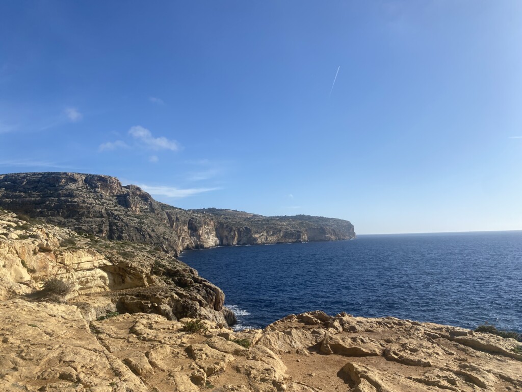
The first part of the hike was along a very nice and wide pavement. It followed the road and offered both resting areas and a great view out over the cliffs. The pavement eventually ended at the Ħaġar Qim Temple. I did not have time to visit the temple itself but did with some help find a route along its fences. A bit further down the hill was also the Mnajdra Temple. Both of these are megalithic temples and were an interesting addition along the route.
I tried to find the route down the cliffs that I had been advised should have been somewhere after the second temple. However, I was unable to find it, maybe it is easier during the summer when there is less vegetation. Instead, I ended up on the road again. Maybe it was an easier hike, but it also required much more attention to traffic.
The road took me away from the coast towards Siggiewi. However, a small road close to the Fawwara Aqueduct led me back toward the coast. It continued to Fawwara, where I passed by the Annunciation Chapel and Our Lady of Mount Carmel Chapel. Both these were quite small, but there were at the same time not many other buildings around.


The Climb at Dingli Cliffs
The road eventually turned into a stony path and the climb higher up the cliffs finally began. I had reached the Dingli Cliffs but did still have a long walk left before I would reach the chapel where we had stopped the day before. The climb consisted of a serpentine path that after a few turns left me at the point of an outgoing cliff. The view from this point was the best during the whole hike. Looking out to my left I could see all the way back to the megalithic temples and to my right, I had the steep Dingli Cliffs. It really gave the whole hike an amazing perspective.
Once I had reached the road again I continued upward towards the St. Mary Magdalene Chapel. It was not long before I could see the chapel and the radar station in its background. So my big question now was, should I be satisfied with this? Or should I continue?


Walking Through Dingli
I decided to continue to the village of Dingli to find somewhere to sit down for a small snack. That was easier thought than done. Instead, I just kept walking until I reached the other side of the village. So what now? What was next up the road? Looking at Google Maps I saw that there was just a short gap between Dingli and Rabat. And I knew what was on the other side of Rabat, the former capital of Malta, the city of Mdina. Wouldn’t that be an interesting end to this hike?


Exploring Rabat
The road between Dingli and Rabat was not as friendly to pedestrians as the earlier roads that I had been taking during the day. Instead, there was plenty of traffic, limited possibilities to see the road ahead, and very narrow paths along the road. I did, however, eventually reach the outer border or Rabat. This is a much larger village and the many narrow streets offered a different environment than the earlier paths during the hike.
The walk through Rabat was nice. Rabat is a lot move lively than Dingli and once I reached its center there were also more tourists around. Not so surprising since Mdina was not just a short distance away. A walk along the traditional Maltese balconies and a few more narrow streets.


Entering the City of Mdina
My hike eventually took me to the gates of Mdina. This former capital of Malta is probably one of the most impressive sights in the whole country and it felt like the perfect end to my hike. But I still felt a need to reach the viewpoint from its high walls. So I walked through the city and until I stood at its wall looking out over the northeastern coast of Malta. From here it is possible to see all the way to St. Julians and even Valletta. But it is that one skyscraper in St. Julians that usually end up as the landmark.
Once I had walked back out from Mdina, I sat down to order a taxi back to Marsaskala. This was also when I let my clock summarize my hike for me. It had been 4 hours and 20 minutes since I left Blue Grotto and I had covered a distance of 20 kilometers. That is a distance that I was more than satisfied with and my feet were even more satisfied to be allowed a rest.


Stay tuned to read more about our 2022 December Visit to Malta. Read more here >>


That coastline looks amazing. The photos of the cities, your hike and the coastline are all great.
It really was an amazing route for a hike. With a few boring parts in between as is almost always the case 🙂