
There has been a thought in my head since Little A and I visited Malta at the start of the pandemic in 2020. At that time, we took a hike from Marsaskala to Marsaxlokk and Birżebbuġa. The thought has been this: How far would I be able to go if I followed the coast to the north instead of the south? Well, actually it is only a short distance north before the direction turns more westwards around the island. Would I be able to walk to Valletta? Or at least to the Three Cities: Birgu, Cospicua, and Senglea?
So, how to best find the answer? Well, I headed out on my hike during our first morning in Malta while Little A and Susann were still resting after traveling the previous day. The sun was shining and with a light breeze, it was a delightful day to spend outdoors.
Read more about Marsaskala & The Three Cities:
- Marsaskala – Exploring Malta
- Birgu (Vittoriosa) – Exploring Malta
- Cospicua (Bormla) – Exploring Malta
- Senglea (Isla) – Exploring Malta
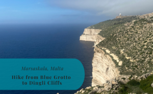
Leaving Marsaskala at Zonqor Point
Walking around Marsaskala Bay in the morning is quite pleasant. The sun was shining this morning and a light breeze was coming from the sea. The streets had just started to settle down again after the morning rush hour. The urban area of Marsaskala continues almost all the way around the bay and up towards Zonqor Point. Here is one of the easternmost points of Malta and it is a popular location for diving. This day there were no divers and the cliffs were battered by the heavy waves that made contact with the land.
From Zonqor Point there is a wide gravel road that continues north along the coast, it was this road that took me further and further away from Marsaskala.


Passing Through Inwadar National Park
Soon after leaving Zonqor Point, I entered the Inwadar National Park. In Maltese the name is Il-Park Nazzjonali tal-Inwadar. The Maltese government established the park in 2016 and it covers the coastal area between Marsaskala, Żabbar, and Xgħajra. The total area is slightly less than one square kilometer.
It was through the Inwadar National Park that the gravel road took me. This is in many parts no road for flip-flops or light sandals, that is for sure. But the view out over the cliffs was great as I followed the road with water on one side and the enclosed farming plateaus on the other. The many stone enclosures and walls along the road gave the certain rural vibe.
The road eventually took me to the Triq il-Wiesgħa Tower. This tower was built in 1659 and it is one of several constructions that for centuries guarded the Maltese coast. It was built by the Order of Saint John and was at the time known as Torre della Giddida. The tower is joined by a World War II pillbox that was built next to it.
When it comes to human construction, it is the watchtower and the pillbox that are the sights of interest within the Inwadar. However, there is also the scenic view of the coast and I made sure to enjoy it as I continued towards Xgħajra.


A Water Stop in Xgħajra
When approaching Xgħajra, there is one large construction that catches the eye in addition to the waters of the Mediterranean. This is the Ta’ Barkat Sewage Treatment Plant. The plant was opened in 2007 and was part of an EU project partly funded by the union. Fortunately there was no smell in the area at the time when I was passing by, I have no clue if that is the case at other times.
At this point, there was only more high cliff to conquer before reaching the village of Xgħajra. I was actually a bit worried that I would have to turn around at this point as there were many temporary, but poorly maintained, fences along the cliffs. Luckily these were not here to block the road, but rather to stop anyone from getting too close to the unstable edge.
Xgħajra felt like a large construction site, as is the case with many of the towns and villages on Malta. The waterfront promenade was very pleasant and the village felt like it was just walking up. Here I took the opportunity to locate a small grocery store and get a new bottle of water. It had started to become quite hot outside as the clock was ticking on, so more water was really neccessary. And at the same time I got the opportunity to see a few more streets in Xgħajra.


A Dead End in Kalkara
The scenic route kind of died after Xgħajra. Once I reached the SmartCity it was construction works all around. Well, it did start with a nice promenade. But soon it was all concrete and temporary walls protecting the construction sites. So I was forced to continue a distance away from the coast towards Kalkara. I really hoped to at least be able to reach the coast again around the tip of the peninsula at Fort Ricasoli.
It would, however, turn out that Fort Ricasoli is a large construction site as well and that is not accessable to the public. So I once more reached gates and had to change my route. Because of this, I headed south towards the Three Cities and by doing so, I also passed through the more urban parts of Kalkara, from where there seems to be no end or even a border betweeen the cities.


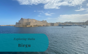
Passing by Birgu
After last year’s visit to Malta, my list of favorite places on the island did indeed need an update. The impressive Fort St. Angelo in Birgu has since been on my top five must-see places. So, while I walked through the outher edges of Birgu, or Vittoriosa as it is also known as, it was hard not to be tempted to make a detour to the fortress. Instead, I decided that I should probably be satisfied with the view of the marina and the neighboring city of Senglea. As a result, I walked down to the waterfront and crossed the small walking bridge to Senglea.


A Hike to Senglea
I had finally decided that my hike should take me to Senglea and be rounded off with the ferry over to Valletta. As a result I continued the short distance to the stop for the Three Cities Ferry to check the timetable. After more than two hours of walking, I was looking forward to take a break. However, I wasn’t really in the mood to wait the 20 minutes until the next ferry. Happy to see that I had reached a late set goal for my hike I started to stroll back from Senglea. There was just no need to take the ferry and I started to think about how to go back to Marsaskala.


Strolling Through Cospicua
The slow stroll took me to Cospicua, the third of the Three Cities, and its busy streets. It was getting close to lunchtime and the cities had really woken up by now. Considering the traffic I was in no hurry to order a taxi or getting on a bus. It would just have resulted in being stuck either way. Instead I started to walk towards the St. Helen’s Gate and the outskirts of Cospicua. The gate itself is really impressive and dates back to 1736. It is the main gate of the Santa Margherita Lines, the fortification walls that protect what today is the Three Cities.
From St. Helen’s gate it is just another short walk before reaching the walls of the Cottonera Lines. Another set of fortifications that encircles the Santa Margherita Lines. Once I had passed through also these walls, I had finally escaped from the extremely well-defended Three Cities.


Final Stop In Fgura
On the other side of the Cottonera Lines is the town of Fgura. From here there is a long line of towns that have grown together, forming a larger urban area. As it turned out, it was the actual end of my hike to Senglea. As a matter of fact, it would only have been a few more kilometers to walk all the way back to Marsaskala. Instead I opted for some shopping before ordering a taxi to drive me back to where I had started about three hours and 13 kilometers earlier. Yes, I had spent quite some time by now enjoying the views and my sorroundings. My feet were more than pleased with not having to walk much further and soon be back in the apartment for a cooling shower.
And if you are considering a hike from Marsaskala, do it! Whether you choose to walk north or south, I’m sure that you will enjoy it.


I wad born in Floriana i was raised in Limsida
I really like the waterfront in Msida, it is in many ways nicer there than in Sliema. And Floriana is charming in its own way. 🙂