My home town of Vagnhärad usually comes with few new surprises. We have spent some time here on the Swedish countryside because of the coronavirus and this time I did, however, notice something that was new. By accident, I found a new walking trail – Vagnhärad Runt. It has probably been here a few years but this was the first time I came across it. The trail, that mostly goes through small roads and forest paths, takes you along some of the most prominent sights of Vagnhärad. Some of these sights include the stream Trosaån, the burial mounds at Fagerhult, the church, and Lånestaheden Nature Reserve.


Vagnhärad Runt – The Walking trail
Vagnhärad Runt is a walking trail or wellness route created by Trosa Municipality. It is about 5.5 kilometers long and runs mostly along nature trails.
Official information: https://www.trosa.se/folkhalsa/vagnharad-runt/
The official starting point is at Hedebyscenen, a small scene that is used for Walpurgis celebrations and when the school ends for the summer. The coordinates are 58.942576 N, 17.476834 E. Here you will also find a map. I’d recommend you to take a photo of it to get directions later on. It is, of course, also possible to start anywhere along the route.


Main Sights Along Vagnhärad Runt
Vagnhärad Runt takes you along some of the most notable sights in Vagnhärad, both when it comes to history as well as natural beauty.
Grave Mounds at Fagerhult and Fornåker
Vagnhärad has several remains from as far back as the stone age. The most visible of these are the grave mounds. In this time and age, they are mostly covered by grass and other vegetation. However, they are still an important part of the local landscape.
Around 15 grave mounds can be found at Fagerhult, next to Bronsåldersvägen. These are mostly covered by vegetation, but clearly visible when you know that they are there. There is another large grave field in the same forest next to Skolvägen. This one is, however, not visible from the path.
At Fornåker, north of Skolvägen, there is another grave field along the path. Here are also the remnants of an old settlement.
Lånestaheden Nature Reserve
Lånestaheden Nature Reserve was created in 2015 and covers almost 30
hectares. This is a mostly forested area but also one of the richest areas of ancient remains in the region of Södermanland. There are recent discoveries of rock carvings within the reserve. These have, however, been covered again to protect them.
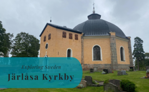
Vagnhärad’s Church
Vagnhärad’s Church dates back to the end of the 13th century and is overlooking the eastern part of Vagnhärad.
Husby Park
Along the river valley is Husby Park. This is an area centered by the old foundations of the mill Husby Kvarn. Just a bit downstream from here, a landslide brought several buildings down towards the river in 1997 and the park has on an annual basis been flooded over the years. When walking by there is, however, a higher chance of seeing mallards than any sign of floods or landslides.


Detailed Route
Hedebyscenen to Lånestavägen
After starting at Hedebyscenen, follow the trail west along the stream Trosaån until you reach Lundbyvägen. Continue right along Lundbyvägen to Centrumvägen, here you need to turn right again. Walk all the way to Bronsåldersvägen, then turn left and then the first gravel path to the right. Follow this road until you reach a paved road.
Once you are on a paved road again, take left up the hill. At the top, you will cross the street, Skolvägen, and continue along a small path through the bushes on the other side. The path will lead you across the fields until you reach the entrance of the Lånestaheden Nature Reserve.
Continue the path through the forest, and make sure not to go off on any of the smaller paths. You will soon reach a slope and at the top, you will take the left path and it will lead you down to the road Gnestavägen. Follow the orange markings and you will find the exit between the woods and be able to cross the road. The Nature Reserve will continue on the other side so enter the path where you find the information sign and continue to follow the orange markings.
The Second Half of Vagnhärad Runt: Lånestavägen and Back to Hedebyscenen
The orange markings take you to the furthest end of the forest and you will eventually find yourself at Lånestavägen. Take right and follow the paved road all the way to the church. It’s easy to spot. At the church, turn right onto Västra Kyrkvägen. There will be a gravel walking path after a short distance to your right. This walking path takes you along the residential area known as “Hagarna” to Centrumvägen. Now you are in the center of Vagnhärad.
Continue along the paved walking path until you have a walking path leading off on your left (not Husbyvägen). The small path takes you to Televägen, which will look like a roundabout with only one exit a bit to your right. Once you’ve crossed the street, continue forward down the slope under the bridge. Now you’ll be at Trosaån again. Walk across the stream and take the first right and then back across the stream again and take left up the slope.
Now you should be at Kvarnvägen, where you should take left and continue until the end of the road. Here you will cross the field along the small path and then cross the road, Stationsvägen. On the other side, you will find a new gravel walking path, but instead of following this, you will take the smaller path across the fields between the stream and the houses. This path will lead you along the stream all the way back to Hedebyscenen.