Yosemite National Park, California | Exploring the United States
Yosemite National Park is a major national park located in the western Sierra Nevada mountains of Central California, in the United States. The park covers an area of approximately 3,081 square kilometers and is situated across several counties. It is one of the most famous and visited national parks in the country, attracting millions of visitors each year. The park is managed by the National Park Service and was designated a UNESCO World Heritage Site in 1984.
The character of Yosemite is defined by its dramatic granite cliffs, its ancient giant sequoia groves, and its numerous waterfalls. The park is home to iconic natural landmarks, including the granite monoliths of El Capitan and Half Dome. Its centerpiece is the Yosemite Valley, a deep, U-shaped glacial valley that is renowned for its scenic beauty. This combination of grand-scale geology and diverse ecosystems has made the park a key site in the history of the American conservation movement.


A Short History of Yosemite National Park
The history of Yosemite is a story of a landscape that has been inhabited for millennia and that later became a cornerstone of the global conservation movement. Its journey from the ancestral home of an indigenous people to a federally protected national park was a pivotal moment in American history. The efforts of early conservationists to protect Yosemite from development set a precedent for the creation of national parks around the world. This legacy of preservation remains central to the park’s identity today.
Indigenous Peoples and Early Exploration
For thousands of years, the area of Yosemite was the home of the indigenous Ahwahnechee people. They lived in the Yosemite Valley, which they called “Ahwahnee,” meaning “place of a gaping mouth.” The arrival of non-indigenous people began with the California Gold Rush in the mid-19th century. The influx of miners and settlers led to conflicts with the local tribes. The Mariposa Battalion entered the valley in 1851 in pursuit of the Ahwahnechee, and it was this group that gave the valley the name “Yosemite.”
The Yosemite Grant and John Muir
As word of the area’s natural beauty spread, concerns grew about the impact of commercial development. In 1864, in the midst of the American Civil War, President Abraham Lincoln signed the Yosemite Grant. This was a landmark piece of legislation that granted the Yosemite Valley and the Mariposa Grove of Giant Sequoias to the state of California for “public use, resort, and recreation.” This was the first time that land had been set aside by the US federal government for preservation and public enjoyment. The Scottish-American naturalist John Muir was a key figure in advocating for the wider protection of the area.
National Park Status and Modern Management
The advocacy of John Muir and others led to the establishment of Yosemite National Park on October 1, 1890. Initially, the new national park did not include the Yosemite Valley and the Mariposa Grove, which remained under state control. The US Army’s cavalry was responsible for patrolling the new park in its early years. This included the “Buffalo Soldiers,” who were African American soldiers and were among the first national park rangers. In 1906, the state of California returned the Yosemite Valley and the Mariposa Grove to federal control, making them part of the national park. The park has been managed by the National Park Service since its creation in 1916.


Things to Do and See
The sights in Yosemite National Park are its world-famous natural landmarks. The main points of interest are concentrated in the Yosemite Valley, but the park also includes vast areas of high-country wilderness, giant sequoia groves, and a network of scenic roads. These sights showcase the geological forces that have shaped the Sierra Nevada mountains.
Yosemite Valley
The Yosemite Valley is the centerpiece of the national park and its most visited area. The valley is approximately 1.6 kilometers wide and 11 kilometers long. It is a classic example of a glacial valley, with a flat floor and high, steep granite walls. The valley contains many of the park’s most famous landmarks, including El Capitan, Half Dome, and Yosemite Falls. The Merced River flows through the valley. A scenic loop road provides access to the main viewpoints and trailheads.
El Capitan
El Capitan is a massive granite monolith that stands at the western end of Yosemite Valley. It rises over 900 meters (3,000 feet) from the valley floor. It is one of the most iconic rock formations in the world. El Capitan is a major destination for experienced rock climbers. The sheer granite face, known as “The Nose,” is considered one of the most challenging and historic climbing routes in the world. The meadows at the base of El Capitan are a popular spot to watch climbers on the rock face.
Half Dome
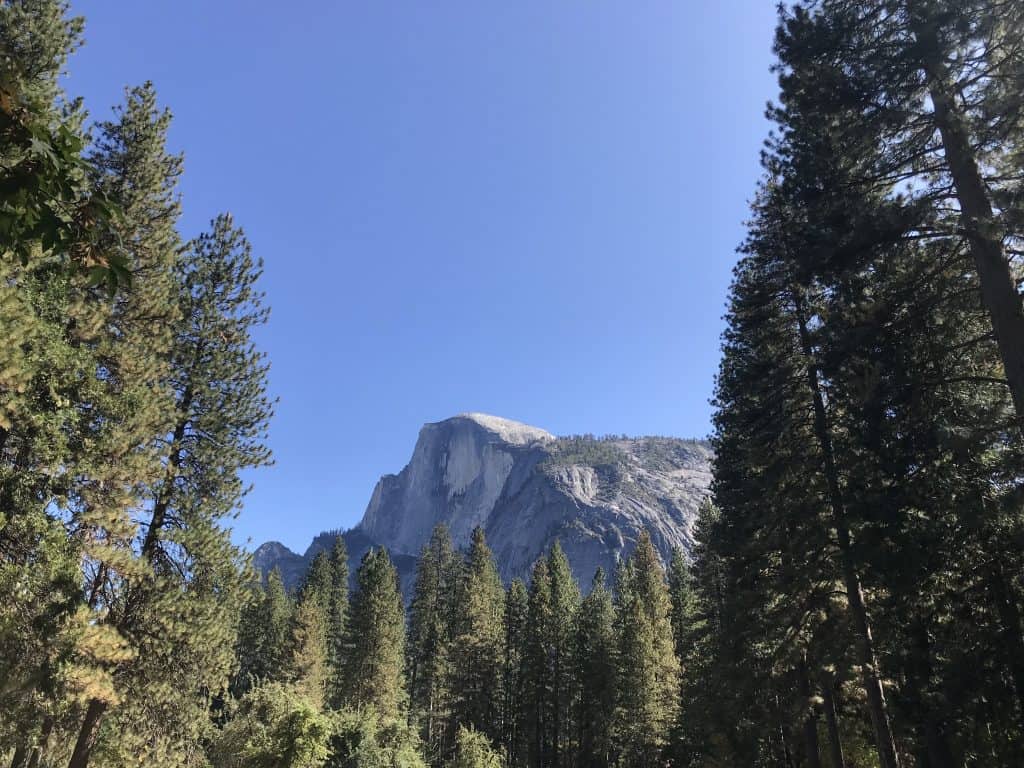
Half Dome is another of Yosemite’s most recognizable granite formations. It is located at the eastern end of the Yosemite Valley. Its distinctive shape is the result of glacial action, which carved away one side of the dome. The summit rises more than 1,444 meters (4,737 feet) above the valley floor. It is a major destination for experienced hikers, who can ascend to the summit with the help of metal cables that are installed on the final steep section. A permit is required for this hike.
Yosemite Falls
Yosemite Falls is one of the tallest waterfalls in the world and the tallest in North America. The waterfall is made up of three separate sections: the Upper Yosemite Fall, the middle cascades, and the Lower Yosemite Fall. The total drop is 739 meters (2,425 feet). The waterfall is fed by snowmelt and is at its most powerful in the late spring. By late summer, the flow of water can be greatly reduced. A short, accessible trail leads to the base of the Lower Fall, while a more strenuous trail leads to the top of the Upper Fall.
Mariposa Grove of Giant Sequoias
The Mariposa Grove is the largest grove of giant sequoia trees in Yosemite National Park. The grove is located in the southern part of the park. It contains several hundred mature giant sequoias (Sequoiadendron giganteum), which are among the largest living things on Earth. Key trees in the grove include the “Grizzly Giant,” which is one of the oldest trees in the grove, and the “California Tunnel Tree,” which had a tunnel cut through it in the 19th century. A network of walking trails allows visitors to explore the grove.
Tuolumne Meadows
Tuolumne Meadows is a large, high-altitude subalpine meadow located in the eastern part of the park. The meadow is situated at an elevation of approximately 2,627 meters (8,619 feet). It is surrounded by granite domes and peaks. The Tuolumne River meanders slowly through the meadow. This area is the main hub for the high country of Yosemite and is a major starting point for hiking and backpacking trips. The area is accessible via the Tioga Road, which is typically open only from late spring to early autumn.
Tioga Road
The Tioga Road is a scenic mountain road that crosses the Sierra Nevada mountains through Yosemite National Park. The road is the highest highway pass in California. It is typically open to vehicles from late May or early June until November. The road provides access to the park’s high country, including Tuolumne Meadows and Tenaya Lake. There are numerous viewpoints and trailheads located along the road. It is a major destination for scenic driving.
Glacier Point
Glacier Point is a famous viewpoint located on the south wall of Yosemite Valley. It is accessible by road during the summer months. The viewpoint offers a commanding, panoramic view of the Yosemite Valley, including Yosemite Falls, Half Dome, and the High Sierra peaks in the distance. It is one of the most popular and accessible viewpoints in the entire national park. Several hiking trails also start from or pass through Glacier Point.

Sports in Yosemite National Park
The primary sports and recreational activities in Yosemite National Park are centered on its natural landscape. The park is a world-class destination for hiking and rock climbing. These activities have a long and storied history in the park and are a key part of its identity.
Hiking
Hiking is the most popular activity in Yosemite National Park. The park has over 1,200 kilometers of marked trails. These range from short, easy walks on the valley floor to strenuous, multi-day backpacking trips in the high country wilderness. Famous day hikes include the Mist Trail, which leads to Vernal Fall and Nevada Fall, and the hike to the top of Yosemite Falls. The park is also the starting point for the John Muir Trail, a famous long-distance trail that runs through the Sierra Nevada.
Rock Climbing
The granite cliffs of Yosemite Valley are a major international center for the sport of rock climbing. The park has been at the forefront of the development of modern climbing techniques for decades. The massive cliffs of El Capitan and Half Dome are considered some of the most iconic and challenging big-wall climbs in the world. The sport has a deep and rich history in the valley, and the area attracts climbers from around the globe.


Getting Around in Yosemite National Park
Navigating Yosemite National Park requires an understanding of its large size and its limited road network. A private vehicle is the most common way to get around, but the park also has a public transport system. Parking in the most popular areas, especially Yosemite Valley, is extremely limited during the peak season.
By Car
A private car is the most common way to explore the different sections of Yosemite. The park has a network of roads that provides access to the main areas, including Yosemite Valley, the Mariposa Grove, and the high country along the Tioga Road. However, driving and parking can be very challenging during the busy summer months. A peak-hours reservation system is often in place, requiring visitors to have a reservation to enter the park during the busiest times.
Yosemite Valley Shuttle
Within the Yosemite Valley, a free shuttle bus system is in operation. The shuttle buses run on a loop that connects all the main accommodation, trailheads, and points of interest in the eastern part of the valley. Using the shuttle is the most practical way to get around the valley once you have parked your car. The service is frequent and helps to reduce traffic congestion.
YARTS (Yosemite Area Regional Transportation System)
The YARTS is a regional bus system that connects the park with the gateway towns located outside its borders. The buses run from towns like Merced, Mariposa, and Mammoth Lakes into the park. Using YARTS is an option for visitors who do not wish to drive their own car into the park. The service is a key part of the regional transport infrastructure.


How to Get to Yosemite National Park
Reaching Yosemite National Park requires travel to the Sierra Nevada mountains in Central California. The park is accessible by road from both the western and eastern sides of the mountain range. The closest major cities are in the Central Valley and the San Francisco Bay Area.
The Open Road: Driving to the Park
Driving is the most common way to reach Yosemite. The park has several main entrances. From the west, Highway 140, Highway 120, and Highway 41 are the primary access routes. These roads connect the park with cities in the Central Valley and the Bay Area. From the east, the Tioga Pass Entrance on Highway 120 is the main access point, but this road is closed during the winter.
Arriving by Air: Nearby Airports
There are no major airports located directly at the park. The closest airport with significant commercial service is Fresno Yosemite International Airport (FAT), which is located about a 2.5-hour drive from the Yosemite Valley. The major international airports of the San Francisco Bay Area (SFO, OAK, SJC) and Sacramento (SMF) are all approximately a 4 to 5-hour drive from the park.
On Track: A Journey by Rail and Bus
It is possible to reach Yosemite using a combination of train and bus. Amtrak, the national passenger rail corporation, operates train services to the cities of Merced and Fresno in the Central Valley. From both of these train stations, the YARTS bus service provides a direct connection into Yosemite National Park. This is a convenient option for those traveling without a car.
Connecting by Coach
Long-distance bus services from companies like Greyhound serve the main towns in the Central Valley, such as Merced and Fresno. From these bus stations, travelers would then need to transfer to the YARTS bus system to complete the journey into the park. There are no direct long-distance bus services that run all the way into the Yosemite Valley.
Driving Distances
The driving distance from 10 regional cities, according to Google Maps:
- Sacramento, CA – 275 kilometers (3 h 20 min)
- San Jose, CA – 301 kilometers (3 h 50 min)
- San Francisco, CA – 304 kilometers (4 h 00 min)
- Reno, NV – 354 kilometers (4 h 50 min)
- Los Angeles, CA – 499 kilometers (5 h 20 min)
- San Diego, CA – 690 kilometers (7 h 10 min)
- Las Vegas, NV – 756 kilometers (7 h 40 min)
- Phoenix, AZ – 1,061 kilometers (10 h 20 min)
- Salt Lake City, UT – 1,178 kilometers (11 h 30 min)
- Portland, OR – 1,189 kilometers (12 h 20 min)
Looking to Explore more of the United States and the Americas?