Boca Tauce, Tenerife | Exploring Spain
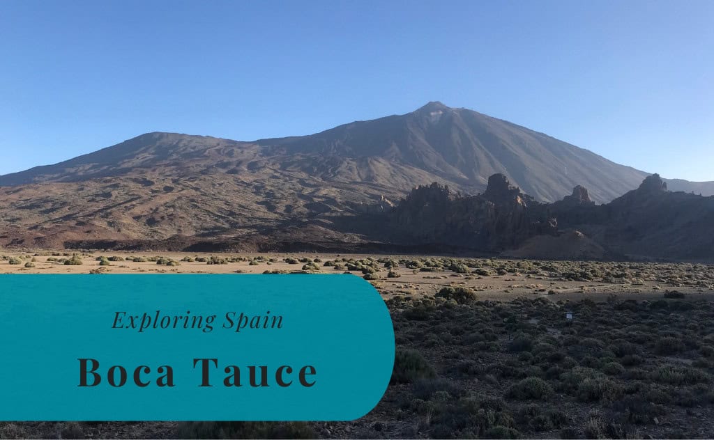
Boca Tauce is a scenic area located in the high mountains of Tenerife, one of the Canary Islands of Spain. It is situated within the magnificent Teide National Park, a UNESCO World Heritage Site. Boca Tauce is not a town but a significant crossroads, and it is the point where the main road from the south, the TF-21, meets the road from the west, the TF-38. The area serves as a major entry point to the Las Cañadas caldera. It is known for its spectacular volcanic landscapes and its breathtaking views of the Mount Teide volcano.
The identity of Boca Tauce is defined by its role as a gateway to the volcanic heart of Tenerife. It is a place of stark and wild beauty, and it is characterized by vast lava fields and unique, eroded rock formations. The area offers some of the most dramatic and classic views of the southern face of Mount Teide and the neighboring peak of Pico Viejo. Today, Boca Tauce is a popular and essential stopping point for visitors who are exploring the national park by car or by bus. It provides a first and unforgettable impression of the park’s unique lunar-like landscapes.


History of Boca Tauce
The history of Boca Tauce is the geological history of the Teide National Park. The entire landscape is the result of millions of years of volcanic activity. The area of Boca Tauce is located on the edge of the massive Las Cañadas caldera, which was formed by the collapse of a much larger, ancient volcano. The more recent eruptions of Pico Viejo and other nearby vents have covered the area in extensive and dramatic lava flows. The human history of the area is one of exploration and scientific study.
A Volcanic Landscape
The landscape around Boca Tauce is a showcase of the volcanic processes that have shaped the island of Tenerife. The area is covered in vast fields of dark, solidified lava, known as “malpaís.” These lava flows came from the eruption of the Narices del Teide (“Teide’s Nostrils”) vents on the side of the Pico Viejo volcano in 1798. This was the last eruption to occur within the boundaries of the national park. The different colors and textures of the lava flows are a testament to the powerful geological forces at work.
A Historic Route
For centuries, the area of Boca Tauce was a remote and inhospitable place, crossed only by the indigenous Guanche people on their seasonal migrations. After the Spanish conquest, a rough track, the “Camino de Chasna,” was established. This historic route connected the northern and southern parts of the island, and it passed through the Boca Tauce area. The construction of the modern TF-21 and TF-38 roads in the 20th century made the area easily accessible for the first time. This opened it up to both tourism and scientific research.
Sights in Boca Tauce
The sights at Boca Tauce are entirely focused on its spectacular and unique volcanic landscape. The main attraction is the magnificent panoramic view of the Mount Teide and Pico Viejo volcanoes, which rise up from the floor of the caldera. The area is also famous for its vast and dramatic lava fields and its many unique and bizarrely shaped rock formations. A stop at the main viewpoint at the Boca Tauce crossroads is an essential part of any visit to the Teide National Park.
The View of Teide and Pico Viejo
The primary reason to stop at Boca Tauce is for the magnificent panoramic view of the two main volcanoes of the park. From the viewpoint, you have a spectacular, unobstructed view of the southern faces of both Mount Teide, the highest peak in Spain, and its sister volcano, Pico Viejo. The view is particularly impressive in the late afternoon, when the setting sun illuminates the different colors of the volcanic rock. It is one of the most classic and photographed views in the entire national park.
The Lava Fields of Narices del Teide
The area around Boca Tauce is covered in the vast and dramatic lava fields from the 1798 eruption of the Narices del Teide vents. A walk through this area is like walking on the moon. The dark, jagged, and twisted lava formations create a surreal and otherworldly landscape. Several hiking trails lead through these lava fields, allowing you to get up close with this unique geological environment.
Roques de Garcia
Located a short drive from Boca Tauce, deeper into the national park, is the famous rock formation of Roques de Garcia. This is a collection of spectacular and bizarrely eroded rock towers. The most famous of these is the Roque Cinchado, which has become a symbol of Tenerife. The Roques de Garcia are a must-see sight for any visitor to the park, and they are easily accessible from the main road.
How to Get to Boca Tauce?
Boca Tauce is located in the Teide National Park in the center of the island of Tenerife. The viewpoint is situated at the junction of the TF-21 and TF-38 roads. The primary gateway for international visitors is Tenerife South Airport (TFS). From the airport and the main tourist resorts of the south, the journey to Boca Tauce is a scenic drive up into the high mountains.
Driving to the Viewpoint
Driving to Boca Tauce is a spectacular journey. From the southern resorts like Costa Adeje and Playa de las Américas, you take the TF-38 road up through the town of Chío. From the town of Vilaflor, you would take the TF-21 road. Both of these scenic mountain roads meet at the Boca Tauce crossroads. The drive from the south takes about one to one and a half hours.
Arriving by Air
The closest airport to Boca Tauce is Tenerife South Airport (TFS). From the airport, the drive to the viewpoint takes about one hour. Tenerife North Airport (TFN) is located further away, and the drive from there takes about one and a half to two hours. From either airport, the easiest way to reach the area is to rent a car.
Driving Distances
The driving distance from 20 regional places, according to Google Maps:
- Vilaflor, Tenerife – 15 kilometers (0 h 20 min)
- Chío, Tenerife – 18 kilometers (0 h 25 min)
- Guía de Isora, Tenerife – 20 kilometers (0 h 25 min)
- Santiago del Teide, Tenerife – 30 kilometers (0 h 40 min)
- Arona, Tenerife – 30 kilometers (0 h 40 min)
- Adeje, Tenerife – 35 kilometers (0 h 45 min)
- Granadilla de Abona, Tenerife – 35 kilometers (0 h 45 min)
- Los Cristianos, Tenerife – 40 kilometers (0 h 50 min)
- Playa de las Américas, Tenerife – 41 kilometers (0 h 50 min)
- Costa Adeje, Tenerife – 43 kilometers (0 h 55 min)
- Los Gigantes, Tenerife – 45 kilometers (1 h 00 min)
- Tenerife South Airport (TFS) – 45 kilometers (0 h 50 min)
- Icod de los Vinos, Tenerife – 45 kilometers (1 h 00 min)
- La Orotava, Tenerife – 50 kilometers (1 h 10 min)
- El Médano, Tenerife – 50 kilometers (1 h 00 min)
- Garachico, Tenerife – 55 kilometers (1 h 15 min)
- Puerto de la Cruz, Tenerife – 55 kilometers (1 h 15 min)
- Candelaria, Tenerife – 60 kilometers (1 h 10 min)
- Santa Cruz de Tenerife, Tenerife – 75 kilometers (1 h 20 min)
- San Cristóbal de La Laguna, Tenerife – 80 kilometers (1 h 25 min)
Looking to Explore more of Spain and Europe?